Suitability analysis, weighted overlay and/or site selection can be calculated via GIS analysis and is ultimately used to determine the best/ideal locations for data dependent on user-defined suitable criteria. Weighted suitability analysis allows one to solve problems that are impacted by various factors and assign varying weights to the data involved. The results provide a more in depth evaluation and gives detailed information for analysis as it ranks locations based on suitability using scoring parameters rather than providing only suitable/not suitable results.
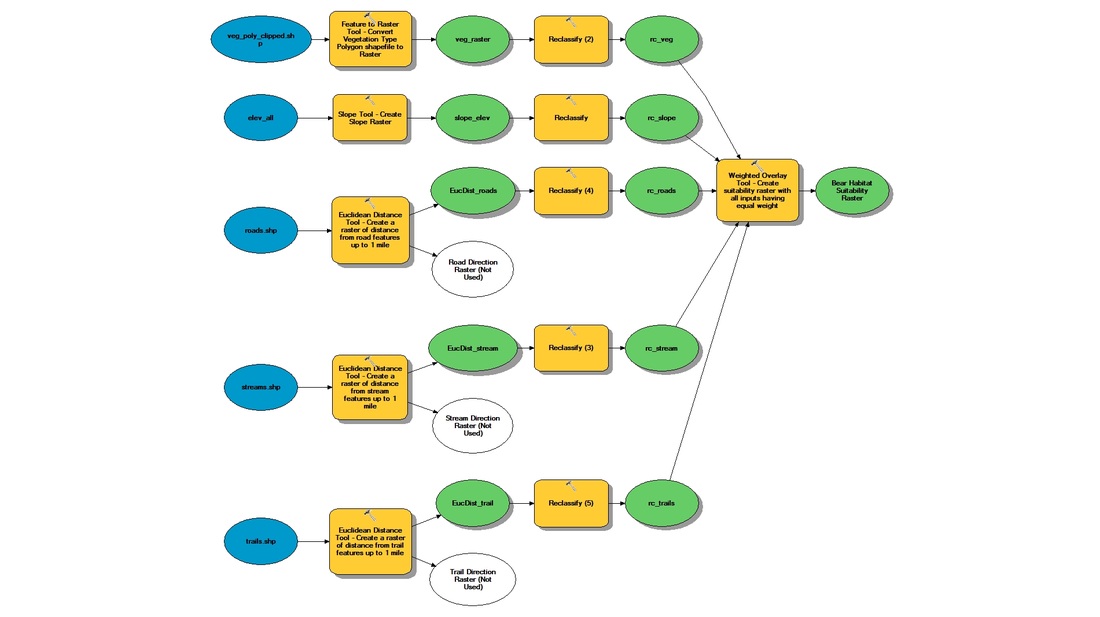
Figure 1. Model builder diagram (ArcMap) used for transforming and reclassifying data layers to perform a weighted overlay to determine areas of suitable bear habitat unlikely to be disturbed by human interaction. Click on diagram for enlarged image.
In the scenario below, The Great Smoky Mountains National Park is experiencing issues with the interaction of the park visitors and the black bears, especially around trails and/or roadways. Wildlife biologists working in the Great Smoky Mountains National Park are seeking assistance with defining areas of black bear habitat that are able to provide the bears with their basic needs while avoiding human contact.
Performing suitability analysis will enable the park to elucidate a multi-site selection with the determination of the different degree of suitability of land for ideal bear habitat. Specifically, the land's suitability for bear habitats that should be conserved using classifying areas such as: least favorable (1), favorable (2) and most favorable (3). These procedures consider the park being able to accomodate, manage and maintain the most favorable areas for bear habitation. The techniques utilized in this project were spatial model creation, flow and weighted overlay. The model serves as a process in which a single operation on a dataset can be represented by connections through linking processes together through various GIS functions and tools. The functions addresses in performing the analysis were: slope, feature to raster, euclidean distance, relcassify and weighted overlay. The weighted overlay tool can provide the implementation of several steps in the general analysis process within a single tool, allowing one to precede suitability modeling or optimal site selection using the criteria provided. This ultimately creates a common evaluation scale of suitability or preference. Guidelines were followed to determine the land's suitability for bear habitats and then compared using a common scale of values to be able to weigh the average of values and create a suitability raster analysis.
Performing suitability analysis will enable the park to elucidate a multi-site selection with the determination of the different degree of suitability of land for ideal bear habitat. Specifically, the land's suitability for bear habitats that should be conserved using classifying areas such as: least favorable (1), favorable (2) and most favorable (3). These procedures consider the park being able to accomodate, manage and maintain the most favorable areas for bear habitation. The techniques utilized in this project were spatial model creation, flow and weighted overlay. The model serves as a process in which a single operation on a dataset can be represented by connections through linking processes together through various GIS functions and tools. The functions addresses in performing the analysis were: slope, feature to raster, euclidean distance, relcassify and weighted overlay. The weighted overlay tool can provide the implementation of several steps in the general analysis process within a single tool, allowing one to precede suitability modeling or optimal site selection using the criteria provided. This ultimately creates a common evaluation scale of suitability or preference. Guidelines were followed to determine the land's suitability for bear habitats and then compared using a common scale of values to be able to weigh the average of values and create a suitability raster analysis.
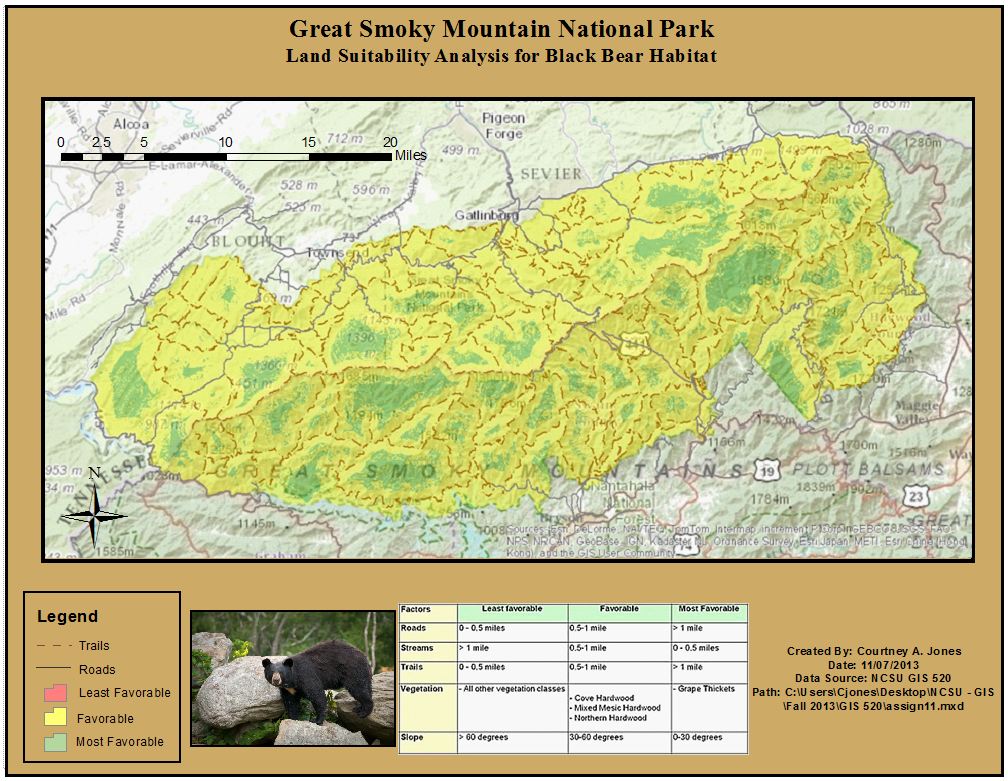
Figure 2. Suitable areas for Black Bear habitat within the Great Smoky Mountains National Park. These areas are according to the defined criteria and are unlikely to be disturbed by human interaction. Click on map for enlarged image.
The techniques addressed within this problem could be used for analyses where one would be searching for areas which fit several criteria to a greater or lesser extent. It is assumed that any field involving wildlife habitat management would benefit from suitability analysis and weighted overlay. Studies could be analyzed showing distance from roads, streams, etc. as well as various other factors that may contribute to habitat quality such as vegetation type, elevation levels, moisture levels, and distance from water sources, etc. Sites found which are lacking these factors could be given more attention and managed appropriately for wildlife.
